Ground penetrating radar (commonly called GPR) is a geophysical method that has been developed over the past thirty years for shallow, high-resolution, subsurface investigations of the earth. GPR uses high frequency pulsed electromagnetic waves (generally 10 MHz to 1,000 MHz) to acquire subsurface information. Energy is propagated downward into the ground and is reflected back to the surface from boundaries at which there are electrical property contrasts. GPR is a method that is commonly used for environmental, engineering, archeological, and other shallow investigations.
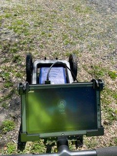
The US Radar Inc. Quantum Imager Triple Frequency GPR system antenna emits three separate signals simultaneously (250 MHz, 500 MHz, 1 GHz). This range of frequencies allows for high resolution imaging, and significant depth of penetration. The US Radar Inc. Quantum Imager Triple Frequency GPR system can achieve depths of penetration up to about 30 feet, but this depth may be greatly reduced due to site-specific conditions. Signal penetration decreases with increased soil conductivity. Conductive materials attenuate or absorb the GPR signal. As depth increases the return signal becomes weaker. Penetration is the greatest in unsaturated sands and fine gravels. Clayey, highly saline or saturated soils, areas covered by steel reinforced concrete, foundry slag, of other highly conductive materials significantly reduces GPR depth of penetration.
The GPR was configured to transmit to a depth of approximately 30 feet below the subsurface, but actual signal penetration was limited to approximately 5-10 feet below ground surface (bgs). The limiting factor was signal attenuation from near surface soils.
The RD7200 precision utility locator uses radio emission to trace the location of metal bearing utilities. This radio emission can be active or passive. Active tracing requires the attachment of a radio transmitter to the utility, passive tracing uses radio emissions that are present on the utility. Underground electrical utilities typically emit radio signals that this device can detect.
The TW-6 is designed to find pipes, cables and other metallic objects such as underground storage tanks. One surveyor can carry both the transmitter and receiver together, making it ideally suited for exploration type searches of ferrous metal masses. Metal detectors of this type operate by generating a magnetic field at the transmitter which causes metallic objects in the subsurface to generate a secondary magnetic field. The induced secondary field is detected by the receiver, which generates an audible tone equal to the strength of the secondary field.